
Coastal experiences on the Solanderleden trail
Hike through dense forests, across vast fields, along old country roads and through the majestic river landscape. Experience local culture and take a break at one of the beautiful rest stops. The Solanderleden trail allows you to experience the multifaceted natural and cultural landscape of the Swedish Lapland coast, up close.
There could hardly have been a more fitting name for this trail than Solanderleden, named after Piteå resident Daniel Solander, apprentice to Carl Linnaeus and himself an internationally renowned botanist, natural scientist and explorer. The innovative hiking trail which will span 180 kilometres upon completion in 2020, will stretch from coast to coast, from Jävre in the south to Luleå Airport in the north. At the time of writing, three sections totalling 60 kilometres have been fully completed and there is already a lot to discover in the flora, fauna and living rural environment of the Swedish Lapland coastland.
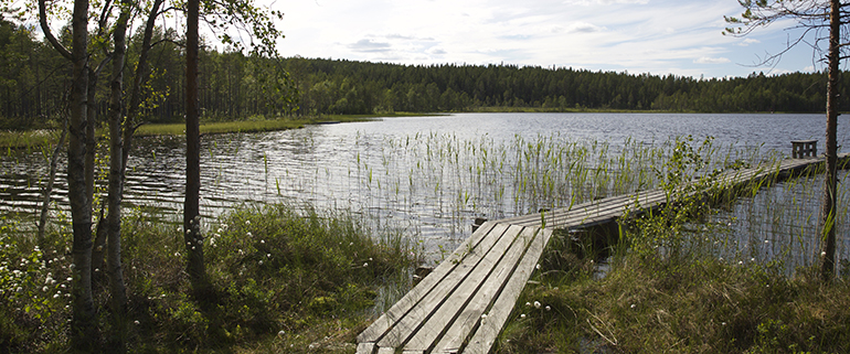 Photo:Britta Elfving Persson
From forestlands to open fields
The southernmost section to have been completed is marked with red and green and begins at the popular local history area of Swensbylijda, approximately 10 km west of Piteå. The trail follows the village trails of Svensbyn and continues into the forest, partially merging with another one of Piteå’s popular hiking trails, Eliasleden. Here, one can make a short detour to the Högberget mountain, offering a beautiful view of the surroundings. The rugged forestland is also home to several easily accessible fishing lakes such as Lake Djuptjärn and Lake Vitsjön. Once out of the forestland, the character of the landscape changes, with large open fields, farmland and grazing pens in pastures. At Hamptjärn you will find the farm store Eufåria (from Swedish får = sheep), selling lamb pelts and crafts made with wool from the Gotland sheep bred at the farm.
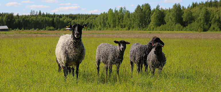 Photo:Britta Elfving Persson
Through fertile farmlands
As the trail goes across Route 373, the next section, marked in yellow, begins. It runs through Infjärden, past the villages of Roknäs, Sjulnäs and Långnäs. Here, one can choose to walk through the flat, fertile farmland, then following the church road, dating back to medieval times. Another option is to walk along the pleasant country road through Långnäs, down to the river where one can follow the river bank. On the outer edge of the cape Näsudden you will find a lovely rest stop with a view of the entire Svensbyfjärden. At the mouth of the Lillpiteälven river you will also find a summer café where you can hire a sauna. Regardless of which way you choose, this section of the trail ends at Böle, by the bridge crossing the Pite River.
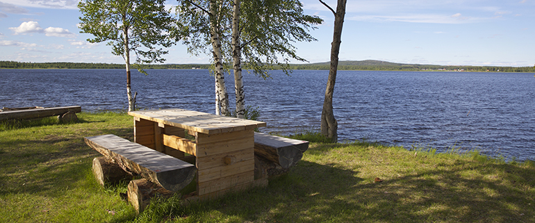 Photo:Britta Elfving Persson
Following in the tracks of raftsmen along the Pite River
Here, Solanderleden changes into the blue trail (Swedish: blå leden) beginning at the renowned tannery in Bölebyn (Bölebyns Garveri) and following the river north, alongside a rafter trail, where remains from the rafting and log driving era are still clearly visible. From here, we would recommend making a short detour to Stormyrbergets Lantgård (Country Farm), offering bed and breakfast, but also travel packages for hikers, with lunch and transfer to and from the trail. This section also passes the villages of Rönnberget, Stridholm and Arnemark, ending at the suspension bridge in Sikfors, which is also the current end point of the Solanderleden trail.
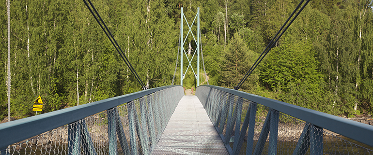 Photo:Britta Elfving Persson
Near the river you will find Sikfors Konferens & Fritidsby (Conference & Leisure Village), serving lunch and offering various types of accommodation. It is easy to hike along Solanderleden, as it is clearly marked with signs, poles, arrows and colour coded markings. New bridges and footbridges make the trail easily accessible. There are plenty of parking options, but remember that the trails do not start and end in the same place. When it comes to choosing paths and places to go, the options are virtually unlimited. You can of course walk entire sections, maybe stopping overnight along the way. However, you can also make shorter day trips and visits to particular sites and rest stops.
There is also the option of hiring canoes and paddling between Skifors and Böle or going on a beaver safari. Many sections are also well suited for mountain biking. Pack a lunch and a bottle of water in your backpack and enjoy it at one of the pleasant rest stops, maybe a fishing rod too if you would like to try your luck at fishing.
Don’t forget to check if you need a fishing licence. Walk by yourself or together with others. Take your time and see the hike for what it is, an amazing way to relax and unwind. You will find that it works.
Basic pioneer maps can be downloaded from the Piteå Council website. For more information, please contact the Tourist Centre in Piteå. More information about Solanderleden can be found in an open group on Facebook, carrying the same name.
Author:Britta Elfving Persson